On the success of last year's fun day, LARA is organising our second Big Lunch as part of the nationwide annual event. Friends, families and neighbours are invited to come and have fun, eat and be merry!
Entrance is a plate of food to share.
West Hackney Recreation Grounds (the green space behind St. Paul's Church, Entrance on Evering Road at the end of Leswin Road).
N16 7UY
Sunday 5th June
1pm to 4pm
We're looking for any volunteers to help set up on the day. Meet up at 11am in the Recreation Grounds.
We will be doing door to door leafleting very soon, any help would be very much appreciated!
See all the pics from last year here
More updates coming soon!
Monday, 9 May 2011

Wednesday, 2 March 2011
Call to Volunteers, Saturday - FREE Pancake extravaganza!!!

A slightly desperate call for Saturday afternoon 5 March.
We are organising a superbe event for Shrove Tuesday in Gillett Square (well, a little bit early) with lots of games and competitions around pancakes. This will be the first event of the Cadbury's Spots vs Stripes events.
I have attached the poster and you can find more info here http://www.gillettsquare.org.uk/webdocs/forthcoming.html
We would need 3 volunteers to help us coordinate the games from 12pm until 4.30pm. You will be provided refreshments and pancakes! (or other food if you don't like pancakes)
It is going to be a lot of fun, tossing and racing with pancakes, pancake limbo, building weirdly shaped ships with Snug play equipment, playing ping pong (I don't know yet where the pancake element will fit in that one.... yet to be devised!), board games
and more
Don't hesitate to contact me e-mail stephanie@vortexjazz.co.uk or phone 07719529313 if you would like more information,
We hope to see you there!
All the best
Stephanie
We are organising a superbe event for Shrove Tuesday in Gillett Square (well, a little bit early) with lots of games and competitions around pancakes. This will be the first event of the Cadbury's Spots vs Stripes events.
I have attached the poster and you can find more info here http://www.gillettsquare.org.uk/webdocs/forthcoming.html
We would need 3 volunteers to help us coordinate the games from 12pm until 4.30pm. You will be provided refreshments and pancakes! (or other food if you don't like pancakes)
It is going to be a lot of fun, tossing and racing with pancakes, pancake limbo, building weirdly shaped ships with Snug play equipment, playing ping pong (I don't know yet where the pancake element will fit in that one.... yet to be devised!), board games
and more
Don't hesitate to contact me e-mail stephanie@vortexjazz.co.uk or phone 07719529313 if you would like more information,
We hope to see you there!
All the best
Stephanie
Sunday, 27 February 2011
STREETSCENE - BROOKE AREA TRAFFIC MANAGEMENT - OPTIONS APPRAISAL
Here is the report from Hackney Council regarding potential traffic calming schemes for the LARA area. If you have any comments about these schemes, please leave a comment at the end of this post or email us at lara.n16@googlemail.com If you would like to see drawings relating to this report we can also send these via email.
There will be a public consultation in March relating to this report.
1. 0 Introduction
As part of the London Borough of Hackney’s Road Safety programme for 2011/2012, funding is available to consult upon (and implement) a 20mph Zone in the Brooke Road area of Stoke Newington.
The 20mph Zone is to be bordered by the Stoke Newington Gyratory (Manse Road, Evering Road, Rectory Road and Stoke Newington High Street).
In addition, several traffic management issues in this area have previously been highlighted by local residents, originating from traffic ‘rat running’ away from the main gyratory. As such, it is to be investigated whether any of the identified problems can be addressed as part of the proposed 20mph Zone works in 2011.
To this end, a meeting was held on the 26th October 2010 between representatives of the Hackney Council Road Safety Team and the Leswin Area Residents Association (LARA) to discuss their concerns with respect to traffic in their area.
Identified Issues
The main traffic problems raised (at the meeting and previously) were:
Rat running traffic along Bayston Road, Darville Road and Leswin Road.
Rat running along Lawrence Buildings.
Illegal left turns into Brooke Road from Lawrence Buildings in order to access Leswin Road.
Wider issues directly relating to the Stoke Newington Gyratory have also been identified. However, these issues relate to Transport for London’s Road Network (TLRN) and fall outside of the scope of the 20mph Zone scheme.
A drawing detailing some initial proposals relating to the 20mph Zone and traffic management schemes (Dwg TT-0220-BR-3, Appendix A) was presented to LARA at the meeting on 26th October.
This summary note will examine the implications of several suggestions made by LARA (Appendix B) and appraise the remedial options available.
OPTIONS APRAISAL
Option 1 - Gated Road Closures (Appendix F, Dwg: TT-0220-BR-8, TT-0220-BR-9)
One measure suggested by LARA in order to prevent ‘rat running’ along their residential streets is to provide gated road closures on Darville Road and Bayston Road. This would effectively cut off the parallel routes through the centre of the Stoke Newington Gyratory.
Advantages
The following advantages are expected from the implementation of permanent gated road closures:
Complete removal of ‘rat-running’ traffic from the residential streets within the Stoke Newington Gyratory. The minimal amount of vehicles displaced from these streets is not expected to significantly affect the capacity of the surrounding gyratory.
Relatively inexpensive to implement, estimated at £25,000.
Disadvantages
The following disadvantages are expected from the implementation of permanent gated road closures:
Severance of access to the local area resulting in inconvenience for residents.
Loss of on-street parking expected at each closure point in order to provide a turn around area for cars. The loss of parking is estimated at 12 spaces in total split equally across the 3 closure points (4 spaces on Bayston Road, 4 spaces on Darville Road, 4 spaces Leswin Road).
A turn around area for larger vehicles is not expected to be feasible at the proposed closure points. The occurrence of large vehicles (e.g. refuse vehicles) having to reverse over long distances will carry an inherent road safety risk.
The Metropolitan Police (Appendix C) have expressed concerns over the proposals (for similar reasons to those above).
The provision of closures on Bayston Road and Darville Road (as requested by LARA) is expected to result in traffic being displaced to Leswin Road, thus requiring additional measures at this location also.
Discussion
Provision of gated closures will of course remove through traffic altogether, a major objective for LARA. However, such measures would incur several disadvantages with respect to access for local residents and emergency services.
Issues regarding access may be resolved through a public consultation process. However, there are also concerns that turn around areas cannot be appropriately provided and loss of parking (estimated at 12 spaces) and additional road safety risks (as a result of reversing vehicles) will arise. The reduction in on-street parking on Bayston Road, Darville Road and Leswin Road is expected to face opposition during consultation with the residents affected.
Furthermore, when reviewing the results of speed and volume surveys (Appendix D) for the roads in question (Darville Road and Bayston Road) a major problem is not evident. Bayston Road recorded 85th percentile speeds of 22mph with a peak weekday average hourly flow of 93 vehicles. No collisions resulting in injury were recorded on these streets in the latest 36 months of data (Appendix E).
The cost of implementing such measures is estimated to be £25,000 (a relatively inexpensive scheme). However, when considering the limited scale of the current issues and the potential for negative impacts on the wider community (i.e. severance of access, loss of parking etc), permanent closures are not considered a proportionate remedial measure to the issues highlighted by LARA.
Option 2 – ‘Point No Entries’
An alternative option to the permanent closures described above, would be to provide ‘point no-entries’ at the same locations (as shown in figure 2.1).
Advantages
The following advantages are expected from the implementation of ‘point no-entries’ on Darville Road and Bayston Road:
Will discourage ‘rat-runners’ from using these residential parallel routes.
Relatively inexpensive to implement, estimated at £6,500.
Will not result in loss of parking or the requirement for turn around areas.
Will not affect emergency service access (emergency vehicles can be exempted from the relevant Traffic Orders).
Will not give rise to the road safety issues resulting from reversing vehicles.
Disadvantages
The following disadvantages are expected from the implementation of ‘point no-entries’ on Darville Road and Bayston Road:
Severance of access to the local area resulting in inconvenience for residents.
Will not be self-enforcing and police enforcement is likely to be impractical. The measures will only serve as a deterrent to some motorists.
Additional street clutter is inevitable, although the existing ‘point no-entry’ on Leswin Road at its junction with Tyssen Road may be removed as part of this proposal and relocated to the Leswin Road/Evering Road junction.
May increase traffic speeds due to limited opposing traffic flow.
Discussion
It is acknowledged that signed ‘point no-entries’ are unlikely to be as effective (i.e. 100% effective) as permanent gated closures. However, they are expected to act as a reasonable deterrent to most ‘rat-running’ motorists. In addition, ad-hoc enforcement by specialist units could be utilised to ensure the measures continue to be as effective as possible.
Therefore, when considering the recorded low traffic speeds, low hourly traffic volumes and excellent existing collision history of the roads in question, such an approach is considered much more proportionate (than gated closures) and will result in fewer negative impacts on the local network and emergency services.
The cost of this option (estimated at £6,500) is expected to be cheaper than the implementation cost of gated road closures and will result in no loss of on-street parking.
Option 3 - Deterrent Measures (e.g. Junction Tables and Pinch Points)
Measures to deter rat-running without altering the priorities (or stopping up) of the local network have also been proposed by LARA as a different approach to solving the identified issues, by way of making the links in question (Bayston Road and Darville Road) unattractive to through traffic.
Specific measures suggested by LARA include:
Provision of junction tables at Tyssen Road j/w Bayston Road and Evering Road j/w Bayston Road (Dwgs: TT-0220-BR-5 & TT-0220-BR-7).
Provision of a pinch point feature midway along Bayston Road (Dwg TT-0220-BR-6).
Advantages
The advantages of this type of approach are as follows:
No severance of access for the local community will result from these measures. This is beneficial for both local residents and the emergency services.
Will help to self enforce the proposed 20mph Zone for the area (due to be consulted upon in 2011).
Disadvantages
The disadvantages of this type of approach are as follows:
When considering that extensive traffic calming already exists on the roads in question, further deterrent (and hence a reduction in rat-running) is not guaranteed by the provision of these additional measures.
The potential for significant speed reduction is not expected as the area is already extensively traffic calmed.
The measures are expected to be costly and will not provide value for money relative to the benefits attributed to them. The two tables (Tyssen Road j/w Bayston Road and Evering Road j/w Bayston Road) have an estimated cost of £60,000 and the proposed pinch-point on Bayston Road is expected to cost £10,000.
Extensive parking loss (estimated at 14 on-street spaces) will be required in order to implement the proposed ‘pinch-point’. This is expected to result in severe opposition during the public consultation process.
Major design issues are associated with the implementation of the junction tables at the two proposed sites as a result of the existing levels and cambers on the carriageway at these locations. Extensive re-profiling is expected to be required and to this end, topographical surveys and carriageway core tests (estimated cost £3,000) will be required.
Discussion
In the current financial climate, ‘value for money’ should be a key consideration before progressing any plans for remedial action.
The construction of junction tables at the proposed locations is expected to be more costly, and achieve less (in terms of addressing the issues identified), than the other options described in this report.
The construction of a pinch point is unlikely to provide a deterrent to ‘rat-running’ traffic (wishing to avoid congestion on the nearby gyratory system) as the existing low flow conditions will not induce any calming in terms of a ‘give and take’ operation at the pinch point. Furthermore, extensive parking loss (up to 14 spaces) is a major barrier to implementing such a measure.
When considering the issues above, these measures are not expected to form part of a viable solution to the current traffic issues being investigated.
OPTIONS SUMMARY
Option 1 – Gated Closures
Cost: £25,000.
Loss of Parking: 12 on-street spaces for turn around areas on Bayston Road, Darville Road and Leswin Road (4 spaces at each gate).
Effectiveness: Total removal of ‘rat-running’.
Traffic Impacts: Severance of access for local residents and emergency services.
Option 2 – ‘Point No-Entries’
Cost: £6,500.
Loss of Parking: No parking loss.
Effectiveness: Medium to high reduction in rat running expected, improved by ad-hoc enforcement.
Traffic Impacts: Access/egress restricted northbound on Bayston Road, Darville Road and Leswin Road with no severance of access for emergency services.
Option 3 – Deterrent Measures (Junction Tables and ‘Pinch-Point’)
Cost: £70,000 (plus additional survey costs).
Loss of Parking: 14 spaces at ‘pinch-point’ feature (Bayston Road).
Effectiveness: Minimal reduction in ‘rat-running’ and speed.
Traffic Impacts: Minimal.
*Note: All of the above options will incur additional consultation costs.
RECOMMENDATIONS
When considering the advantages and disadvantages of the proposed traffic management measures listed above, it is recommended that the most appropriate option (subject to further public consultation) is the provision of Option 2 - ‘point no-entries’ on Bayston Road, Darville Road and Leswin Road (relocated from junction with Tyssen Road).
This is the most proportionate solution when examining the scale of the traffic issues evident from the speed and volume surveys undertaken and the existing collision history in the area.
Few adverse impacts are envisaged from the provision of such measures and it is hoped that they will provide sufficient deterrent so as to reduce the volume of through traffic currently using the parallel residential links.
In order to maintain effectiveness and driver compliance of the ‘point no entries’, ad-hoc enforcement measures (i.e. temporary camera enforcement) may be considered as part of the overall package of proposals.
Any measures must be consulted upon with the wider community in order to gain a full cross section of local opinion prior to any commitments with respect to implementing the proposals.
There will be a public consultation in March relating to this report.
1. 0 Introduction
As part of the London Borough of Hackney’s Road Safety programme for 2011/2012, funding is available to consult upon (and implement) a 20mph Zone in the Brooke Road area of Stoke Newington.
The 20mph Zone is to be bordered by the Stoke Newington Gyratory (Manse Road, Evering Road, Rectory Road and Stoke Newington High Street).
In addition, several traffic management issues in this area have previously been highlighted by local residents, originating from traffic ‘rat running’ away from the main gyratory. As such, it is to be investigated whether any of the identified problems can be addressed as part of the proposed 20mph Zone works in 2011.
To this end, a meeting was held on the 26th October 2010 between representatives of the Hackney Council Road Safety Team and the Leswin Area Residents Association (LARA) to discuss their concerns with respect to traffic in their area.
Identified Issues
The main traffic problems raised (at the meeting and previously) were:
Rat running traffic along Bayston Road, Darville Road and Leswin Road.
Rat running along Lawrence Buildings.
Illegal left turns into Brooke Road from Lawrence Buildings in order to access Leswin Road.
Wider issues directly relating to the Stoke Newington Gyratory have also been identified. However, these issues relate to Transport for London’s Road Network (TLRN) and fall outside of the scope of the 20mph Zone scheme.
A drawing detailing some initial proposals relating to the 20mph Zone and traffic management schemes (Dwg TT-0220-BR-3, Appendix A) was presented to LARA at the meeting on 26th October.
This summary note will examine the implications of several suggestions made by LARA (Appendix B) and appraise the remedial options available.
OPTIONS APRAISAL
Option 1 - Gated Road Closures (Appendix F, Dwg: TT-0220-BR-8, TT-0220-BR-9)
One measure suggested by LARA in order to prevent ‘rat running’ along their residential streets is to provide gated road closures on Darville Road and Bayston Road. This would effectively cut off the parallel routes through the centre of the Stoke Newington Gyratory.
Advantages
The following advantages are expected from the implementation of permanent gated road closures:
Complete removal of ‘rat-running’ traffic from the residential streets within the Stoke Newington Gyratory. The minimal amount of vehicles displaced from these streets is not expected to significantly affect the capacity of the surrounding gyratory.
Relatively inexpensive to implement, estimated at £25,000.
Disadvantages
The following disadvantages are expected from the implementation of permanent gated road closures:
Severance of access to the local area resulting in inconvenience for residents.
Loss of on-street parking expected at each closure point in order to provide a turn around area for cars. The loss of parking is estimated at 12 spaces in total split equally across the 3 closure points (4 spaces on Bayston Road, 4 spaces on Darville Road, 4 spaces Leswin Road).
A turn around area for larger vehicles is not expected to be feasible at the proposed closure points. The occurrence of large vehicles (e.g. refuse vehicles) having to reverse over long distances will carry an inherent road safety risk.
The Metropolitan Police (Appendix C) have expressed concerns over the proposals (for similar reasons to those above).
The provision of closures on Bayston Road and Darville Road (as requested by LARA) is expected to result in traffic being displaced to Leswin Road, thus requiring additional measures at this location also.
Discussion
Provision of gated closures will of course remove through traffic altogether, a major objective for LARA. However, such measures would incur several disadvantages with respect to access for local residents and emergency services.
Issues regarding access may be resolved through a public consultation process. However, there are also concerns that turn around areas cannot be appropriately provided and loss of parking (estimated at 12 spaces) and additional road safety risks (as a result of reversing vehicles) will arise. The reduction in on-street parking on Bayston Road, Darville Road and Leswin Road is expected to face opposition during consultation with the residents affected.
Furthermore, when reviewing the results of speed and volume surveys (Appendix D) for the roads in question (Darville Road and Bayston Road) a major problem is not evident. Bayston Road recorded 85th percentile speeds of 22mph with a peak weekday average hourly flow of 93 vehicles. No collisions resulting in injury were recorded on these streets in the latest 36 months of data (Appendix E).
The cost of implementing such measures is estimated to be £25,000 (a relatively inexpensive scheme). However, when considering the limited scale of the current issues and the potential for negative impacts on the wider community (i.e. severance of access, loss of parking etc), permanent closures are not considered a proportionate remedial measure to the issues highlighted by LARA.
Option 2 – ‘Point No Entries’
An alternative option to the permanent closures described above, would be to provide ‘point no-entries’ at the same locations (as shown in figure 2.1).
Advantages
The following advantages are expected from the implementation of ‘point no-entries’ on Darville Road and Bayston Road:
Will discourage ‘rat-runners’ from using these residential parallel routes.
Relatively inexpensive to implement, estimated at £6,500.
Will not result in loss of parking or the requirement for turn around areas.
Will not affect emergency service access (emergency vehicles can be exempted from the relevant Traffic Orders).
Will not give rise to the road safety issues resulting from reversing vehicles.
Disadvantages
The following disadvantages are expected from the implementation of ‘point no-entries’ on Darville Road and Bayston Road:
Severance of access to the local area resulting in inconvenience for residents.
Will not be self-enforcing and police enforcement is likely to be impractical. The measures will only serve as a deterrent to some motorists.
Additional street clutter is inevitable, although the existing ‘point no-entry’ on Leswin Road at its junction with Tyssen Road may be removed as part of this proposal and relocated to the Leswin Road/Evering Road junction.
May increase traffic speeds due to limited opposing traffic flow.
Discussion
It is acknowledged that signed ‘point no-entries’ are unlikely to be as effective (i.e. 100% effective) as permanent gated closures. However, they are expected to act as a reasonable deterrent to most ‘rat-running’ motorists. In addition, ad-hoc enforcement by specialist units could be utilised to ensure the measures continue to be as effective as possible.
Therefore, when considering the recorded low traffic speeds, low hourly traffic volumes and excellent existing collision history of the roads in question, such an approach is considered much more proportionate (than gated closures) and will result in fewer negative impacts on the local network and emergency services.
The cost of this option (estimated at £6,500) is expected to be cheaper than the implementation cost of gated road closures and will result in no loss of on-street parking.
Option 3 - Deterrent Measures (e.g. Junction Tables and Pinch Points)
Measures to deter rat-running without altering the priorities (or stopping up) of the local network have also been proposed by LARA as a different approach to solving the identified issues, by way of making the links in question (Bayston Road and Darville Road) unattractive to through traffic.
Specific measures suggested by LARA include:
Provision of junction tables at Tyssen Road j/w Bayston Road and Evering Road j/w Bayston Road (Dwgs: TT-0220-BR-5 & TT-0220-BR-7).
Provision of a pinch point feature midway along Bayston Road (Dwg TT-0220-BR-6).
Advantages
The advantages of this type of approach are as follows:
No severance of access for the local community will result from these measures. This is beneficial for both local residents and the emergency services.
Will help to self enforce the proposed 20mph Zone for the area (due to be consulted upon in 2011).
Disadvantages
The disadvantages of this type of approach are as follows:
When considering that extensive traffic calming already exists on the roads in question, further deterrent (and hence a reduction in rat-running) is not guaranteed by the provision of these additional measures.
The potential for significant speed reduction is not expected as the area is already extensively traffic calmed.
The measures are expected to be costly and will not provide value for money relative to the benefits attributed to them. The two tables (Tyssen Road j/w Bayston Road and Evering Road j/w Bayston Road) have an estimated cost of £60,000 and the proposed pinch-point on Bayston Road is expected to cost £10,000.
Extensive parking loss (estimated at 14 on-street spaces) will be required in order to implement the proposed ‘pinch-point’. This is expected to result in severe opposition during the public consultation process.
Major design issues are associated with the implementation of the junction tables at the two proposed sites as a result of the existing levels and cambers on the carriageway at these locations. Extensive re-profiling is expected to be required and to this end, topographical surveys and carriageway core tests (estimated cost £3,000) will be required.
Discussion
In the current financial climate, ‘value for money’ should be a key consideration before progressing any plans for remedial action.
The construction of junction tables at the proposed locations is expected to be more costly, and achieve less (in terms of addressing the issues identified), than the other options described in this report.
The construction of a pinch point is unlikely to provide a deterrent to ‘rat-running’ traffic (wishing to avoid congestion on the nearby gyratory system) as the existing low flow conditions will not induce any calming in terms of a ‘give and take’ operation at the pinch point. Furthermore, extensive parking loss (up to 14 spaces) is a major barrier to implementing such a measure.
When considering the issues above, these measures are not expected to form part of a viable solution to the current traffic issues being investigated.
OPTIONS SUMMARY
Option 1 – Gated Closures
Cost: £25,000.
Loss of Parking: 12 on-street spaces for turn around areas on Bayston Road, Darville Road and Leswin Road (4 spaces at each gate).
Effectiveness: Total removal of ‘rat-running’.
Traffic Impacts: Severance of access for local residents and emergency services.
Option 2 – ‘Point No-Entries’
Cost: £6,500.
Loss of Parking: No parking loss.
Effectiveness: Medium to high reduction in rat running expected, improved by ad-hoc enforcement.
Traffic Impacts: Access/egress restricted northbound on Bayston Road, Darville Road and Leswin Road with no severance of access for emergency services.
Option 3 – Deterrent Measures (Junction Tables and ‘Pinch-Point’)
Cost: £70,000 (plus additional survey costs).
Loss of Parking: 14 spaces at ‘pinch-point’ feature (Bayston Road).
Effectiveness: Minimal reduction in ‘rat-running’ and speed.
Traffic Impacts: Minimal.
*Note: All of the above options will incur additional consultation costs.
RECOMMENDATIONS
When considering the advantages and disadvantages of the proposed traffic management measures listed above, it is recommended that the most appropriate option (subject to further public consultation) is the provision of Option 2 - ‘point no-entries’ on Bayston Road, Darville Road and Leswin Road (relocated from junction with Tyssen Road).
This is the most proportionate solution when examining the scale of the traffic issues evident from the speed and volume surveys undertaken and the existing collision history in the area.
Few adverse impacts are envisaged from the provision of such measures and it is hoped that they will provide sufficient deterrent so as to reduce the volume of through traffic currently using the parallel residential links.
In order to maintain effectiveness and driver compliance of the ‘point no entries’, ad-hoc enforcement measures (i.e. temporary camera enforcement) may be considered as part of the overall package of proposals.
Any measures must be consulted upon with the wider community in order to gain a full cross section of local opinion prior to any commitments with respect to implementing the proposals.
Wednesday, 23 February 2011
Update - LARA inclusive traffic campaign One-way system
Are you awaiting the outcome of the Stoke Newington Gyratory Consultation recently carried out by Hackney? Well don’t hold your breath. Whilst Hackney’s intentions are worthy no doubt, it doesn’t seem as if they have entered into a meaningful dialogue with TfL about the issue as yet. At our meeting in October with representatives from both sides present it quickly became clear that there isn’t a lot of talking going on between them right now.
In their own words TfL’s priorites are to implement the mayor’s traffic policies which are A) to ensure a smooth traffic flow (in our case on the A10 artery into London, which includes the SN gyratory) and B) to promote cycling in London. Apparently A) only applies exclusively to vehicular traffic and B) is only for lycra-clad city workers commuting up and down the A10 at lightning speed and with no regard for their own or anyone else’s safety.
However, when questioned TfL conceded that ‘We all realise that the one way system has created an environment which is not ideally suited for non car modes, but going forward nobody has been able to identify an alternative workable solution’.
They have confirmed that the Cycle Super Highway proposal will look at providing a cycle facility for the entire gyratory system. The design for the super highway is scheduled to start this spring (2011) and a two way cycle facility on the High St might be considered. We are keeping in touch with TfL so watch this space for updates – that is the best we can do right now. Does Boris Johnson care about us? - I think not.
On the other matters raised regarding TfL-owned roads they were similarly uncompromising. Here some answers received from TfL in response to the issues we raised with them…
Lack of safety on / inadequacy of existing pedestrian crossings across SN High St (Sainsburys), Evering / Manse Rd and Rectory Road) In the past three years there have been 17 personal injury collisions (all slight injuries) on the High Street, of which five involved pedestrians (29%) which is marginally lower than you would expect on the Transport for London Road Network (TLRN) when compared to the Borough average (Hackney 31.7%). In terms of converting the zebra crossing on Manse Road to a pelican, a review of the collision information shows that there have been just 4 injury collisions along this section, and none of these involved pedestrians. Unfortunately the statistics for this location would not meet TfL’s criteria for installing new signals on the network.
Insufficient number of crossings to Manse/Evering Road, Rectory Road but particular across SN High Street (additional crossing should be considered by Tesco’s) – A site visit to Stoke Newington High Street revealed a number of physical issues which would prevent the installation of a new crossing point. The parking and loading for the local businesses extend down both sides of the road, and a new crossing would require their removal over a distance of approximately 40m (on both sides of the road) to facilitate the zigzag markings. Based on previous correspondence with traders in the area this proposal would be fiercely resisted (they have been campaigning for more loading and parking). The signals would also be required to be sited at least 20m from a side road entrance to meet visibility requirements. Unfortunately the number of accesses onto the A10 mean that it would not be possible to site a new crossing near the Tesco’s.
The pedestrian facilities on Manse / Evering Road are sufficient to meet the desire lines and as there are no collisions involving pedestrians there would be no justification to provide an additional crossing point.
Excessive pedestrian waiting time at junction with Evering Road – The signal timings change according to set plans for each time of day. The cycle time varies from 50 – 60 seconds (the time it takes for all the movements to take place). This means that a pedestrian should have to wait on average 30 seconds for the green man to be displayed, which is well within agreed parameters.
TfL proposals – TfL is currently designing an improvement at the Stoke Newington High St junction with Brooke Road. The focus of the proposal is improving journey times and reducing congestion. The design is almost complete, however there is currently no funding to implement the measures in light of the recent budget cuts. TfL is also developing a proposal for the Manse Road junction with Rectory Road, as the junction is too narrow for HGVs approaching from the south. This proposal is still at the feasibility stage.
TfL clearly doesn’t see local traffic as their remit – and someone will have to die first before the statistics will allow them to look at a problem?? No doubt things will change with the revival of the West Hackney Recreation ground – which is definitely on the cards now with the application for funding going ahead soon.
We are looking at a number of routes to gain more and better attention for our problems here so watch this space.
Brooke Area 20 mph zone
Some good news here – Following our meeting in October LBH has sent us their draft traffic appraisal. This document looks at three options for the prevention of rat-running and excessive speed within the LARA area, in addition to the 20 miles per hour speed limit throughout. Their Option 2 – no-entry signs at the southern ends of Leswin, Bayston and Darville Road, seems to be the favoured proposal. LBH are planning a Consultation in March. We’d like to publish the draft appraisal on the blog as soon as possible and are awaiting LBH’s ok for this.
AJ
In their own words TfL’s priorites are to implement the mayor’s traffic policies which are A) to ensure a smooth traffic flow (in our case on the A10 artery into London, which includes the SN gyratory) and B) to promote cycling in London. Apparently A) only applies exclusively to vehicular traffic and B) is only for lycra-clad city workers commuting up and down the A10 at lightning speed and with no regard for their own or anyone else’s safety.
However, when questioned TfL conceded that ‘We all realise that the one way system has created an environment which is not ideally suited for non car modes, but going forward nobody has been able to identify an alternative workable solution’.
They have confirmed that the Cycle Super Highway proposal will look at providing a cycle facility for the entire gyratory system. The design for the super highway is scheduled to start this spring (2011) and a two way cycle facility on the High St might be considered. We are keeping in touch with TfL so watch this space for updates – that is the best we can do right now. Does Boris Johnson care about us? - I think not.
On the other matters raised regarding TfL-owned roads they were similarly uncompromising. Here some answers received from TfL in response to the issues we raised with them…
Lack of safety on / inadequacy of existing pedestrian crossings across SN High St (Sainsburys), Evering / Manse Rd and Rectory Road) In the past three years there have been 17 personal injury collisions (all slight injuries) on the High Street, of which five involved pedestrians (29%) which is marginally lower than you would expect on the Transport for London Road Network (TLRN) when compared to the Borough average (Hackney 31.7%). In terms of converting the zebra crossing on Manse Road to a pelican, a review of the collision information shows that there have been just 4 injury collisions along this section, and none of these involved pedestrians. Unfortunately the statistics for this location would not meet TfL’s criteria for installing new signals on the network.
Insufficient number of crossings to Manse/Evering Road, Rectory Road but particular across SN High Street (additional crossing should be considered by Tesco’s) – A site visit to Stoke Newington High Street revealed a number of physical issues which would prevent the installation of a new crossing point. The parking and loading for the local businesses extend down both sides of the road, and a new crossing would require their removal over a distance of approximately 40m (on both sides of the road) to facilitate the zigzag markings. Based on previous correspondence with traders in the area this proposal would be fiercely resisted (they have been campaigning for more loading and parking). The signals would also be required to be sited at least 20m from a side road entrance to meet visibility requirements. Unfortunately the number of accesses onto the A10 mean that it would not be possible to site a new crossing near the Tesco’s.
The pedestrian facilities on Manse / Evering Road are sufficient to meet the desire lines and as there are no collisions involving pedestrians there would be no justification to provide an additional crossing point.
Excessive pedestrian waiting time at junction with Evering Road – The signal timings change according to set plans for each time of day. The cycle time varies from 50 – 60 seconds (the time it takes for all the movements to take place). This means that a pedestrian should have to wait on average 30 seconds for the green man to be displayed, which is well within agreed parameters.
TfL proposals – TfL is currently designing an improvement at the Stoke Newington High St junction with Brooke Road. The focus of the proposal is improving journey times and reducing congestion. The design is almost complete, however there is currently no funding to implement the measures in light of the recent budget cuts. TfL is also developing a proposal for the Manse Road junction with Rectory Road, as the junction is too narrow for HGVs approaching from the south. This proposal is still at the feasibility stage.
TfL clearly doesn’t see local traffic as their remit – and someone will have to die first before the statistics will allow them to look at a problem?? No doubt things will change with the revival of the West Hackney Recreation ground – which is definitely on the cards now with the application for funding going ahead soon.
We are looking at a number of routes to gain more and better attention for our problems here so watch this space.
Brooke Area 20 mph zone
Some good news here – Following our meeting in October LBH has sent us their draft traffic appraisal. This document looks at three options for the prevention of rat-running and excessive speed within the LARA area, in addition to the 20 miles per hour speed limit throughout. Their Option 2 – no-entry signs at the southern ends of Leswin, Bayston and Darville Road, seems to be the favoured proposal. LBH are planning a Consultation in March. We’d like to publish the draft appraisal on the blog as soon as possible and are awaiting LBH’s ok for this.
AJ
Tuesday, 8 February 2011
SERIOUSLY IMPORTANT MEETING ABOUT WEST HACKNEY RECREATION GROUND - WEDNESDAY 16th FEBRUARY @ 7:30pm in St PAUL'S CHURCH

Anyone interested in what happens to West Hackney Recreation Ground, please read this note from Revd Niall Weir and come along to the meeting
Dear Friends,
Greetings from St Paul's Church.
As you may know, we are just about to submit an application to The Heritage Lottery Fund for a grant to regenerate West Hackney Recreation Ground.
We've already had one grant of £75,000 from The London Marathon Trust to install a fabulous play area should the regeneration of the Recreation Ground go ahead.
In making up their minds about whether or not to award the grant, The Heritage Lottery Fund needs evidence of local support for this venture and we can best achieve this by reporting to them a great turnout at our forthcoming meeting of the new User Group next Wednesday at St Paul's Church - please see the attachment for further details.
As someone who I know would love to see this regeneration programme happen, not just for our enjoyment but for that of local residents for years to come, may I urge you to come along to this meeting? It will last no more than one hour and there will be enough wine on offer to float a ship.
As well as showing the HLF that there is a load of local support, you can also come along and catch up with recent developments around the project.
Do come, do bring your neighbours - it would be an evening well spent!
With very best wishes,
Niall
St Paul's West Hackney - stpaulswesthackney.org
________________________________________________________________________________________________
From : The Revd Niall Weir
306 Amhurst Rd : West Hackney : London N16 7UE : 020 7254 3235 : 07840 762783 : Fax 0871 714 6005
Thursday, 6 January 2011
St Paul’s West Hackney
St Paul’s West Hackney & The Hackney Society
present
WEST HACKNEY – PAST, PRESENT & FUTURE
an evening talk to mark the 50th anniversary
of the Consecration of St Paul’s Church, West Hackney
MONDAY 17th JANUARY 2011 at 7:00pm
ST PAUL’S CHURCH, WEST HACKNEY
on the corner of Stoke Newington Rd & Amhurst Rd, London N16 7UY
St Paul’s West Hackney & The Hackney Society
present
WEST HACKNEY – PAST, PRESENT & FUTURE
an evening talk to mark the 50th anniversary
of the Consecration of St Paul’s Church, West Hackney
MONDAY 17th JANUARY 2011 at 7:00pm
ST PAUL’S CHURCH, WEST HACKNEY
on the corner of Stoke Newington Rd & Amhurst Rd, London N16 7UY
THE LOST PARISH CHURCH OF WEST HACKNEY
Dr Ann RobeyAnn Robey – architectural historian and heritage consultant – will talk about the creation of the parish of West Hackney in 1824, what the area was like at the time
and about the architect Robert Smirke and his design for the original West Hackney Church and how that church was destroyed in the Blitz
GOD'S ACRE? CITY CHURCHYARDS: PAST, PRESENT AND FUTURE.
Professor Ken WorpoleThe city churchyard was once a place central to the popular and literary imagination.
Their closure in the mid-19th century for health & sanitation reasons left many as historical archives.
Some have since been re-landscaped as pocket gardens or turned into wildlife conservation areas
as part of the 'Living Churchyard' project. In this talk local writer and academic, Ken Worpole,
will discuss the place of these remaining churchyards in the contemporary townscape.
CACHEMAILLE DAY AND THE CHALLENGE OF RECONSTRUCTION
Suzanne WatersSuzanne Waters- architectural historian and Hackney resident for over 20 years – will talk about the architect Nugent Cachemaille Day, architect of St Paul’s Church, in the context of his church architecture in Hackney.
Her talk will include a tour of the church looking at its architecture and design
Entrance is free to all
The talk will last for approximately one hour and will be followed by refreshments
Tuesday, 30 November 2010
LARA Full Meeting & AGM
Thursday 9th Dec 2010, 7pm, St Paul's Church Hall
(Corner of High Road and Evering Road)
This meeting will give an update from the last full meeting on the local traffic issues (see article below). We will also be electing the committee and officers for the next year.
All residents of the LARA area welcome
Help build your community. We need residents to get involved on the committee. We want to hear your views and we need your participation to help LARA succeed
Look out for the Newsletter coming through your door!
(Corner of High Road and Evering Road)
This meeting will give an update from the last full meeting on the local traffic issues (see article below). We will also be electing the committee and officers for the next year.
All residents of the LARA area welcome
Help build your community. We need residents to get involved on the committee. We want to hear your views and we need your participation to help LARA succeed
Look out for the Newsletter coming through your door!
Sunday, 24 October 2010
Open Letter Re: Stoke Newington Gyratory
In response to an article written in the Hackney Gazette recently, here is an open letter from our chair, Jim Westwood, on behalf of the LARA Commitee and its residents:
Just a reminder about the Walkabout this coming Tuesday as part of the on going consultation for the 20mph zone on our streets. All welcome. Please see previous post.
Dear Sir/Madam
I was very interested to read your article about the Stoke Newington gyratory system. While the consultation is welcome, many residents who live within the gyratory system have been discussing this issue for some time. Leswin Area Residents Association (LARA) recently held a well attended meeting on the issues faced by residents living within the one-way system.
Your readers, and others, may be interested to note that the LARA members do not, in the first instance, see the retaining or abolition of the gyratory system as their main priority. What they do see as their main priority is taming the roads around the gyratory to make them safer and more pedestrian/cyclist friendly and improving the environment and safety of the gyratory’s internal streets. For example, more safe crossing points, traffic calming measures on the gyratory, stopping the rat running that goes on through our streets and creating a 20mph zone.
In your article, Trevor Parsons of LCC implies that reverting back to two-way traffic will cure if not all then most of the ills of the one-way system. Many of the LARA residents are not so sure. They fear that whichever traffic system we end up with, the problems our children, elderly and disabled residents face in crossing the High road and other roads will not disappear.
Stoke Newington High Road has been revitalised as a shopping centre over recent years. With the introduction of supermarkets such as Tesco’s and Sainsbury’s alongside the more established shops such as General Woodwork, their is more reason and temptation to cross the road other than at the current few and far between safe crossing points. Around the gyratory system the traffic must be slowed down by introducing traffic calming measures. We also need a lot more places where residents can cross the road in safety.
The issue of whether we stay with or reverse the gyratory system is a complex and costly one that could drag on for a long time. In the meantime, we still have cars racing at high speed along Rectory Road, Evering Road and Stoke Newington High Road as there are no deterrents in place to stop them. ‘Taming’ the gyratory system and improving the local environment within it could be achieved quickly and for a lot less money.
Just a reminder about the Walkabout this coming Tuesday as part of the on going consultation for the 20mph zone on our streets. All welcome. Please see previous post.
Dear Sir/Madam
I was very interested to read your article about the Stoke Newington gyratory system. While the consultation is welcome, many residents who live within the gyratory system have been discussing this issue for some time. Leswin Area Residents Association (LARA) recently held a well attended meeting on the issues faced by residents living within the one-way system.
Your readers, and others, may be interested to note that the LARA members do not, in the first instance, see the retaining or abolition of the gyratory system as their main priority. What they do see as their main priority is taming the roads around the gyratory to make them safer and more pedestrian/cyclist friendly and improving the environment and safety of the gyratory’s internal streets. For example, more safe crossing points, traffic calming measures on the gyratory, stopping the rat running that goes on through our streets and creating a 20mph zone.
In your article, Trevor Parsons of LCC implies that reverting back to two-way traffic will cure if not all then most of the ills of the one-way system. Many of the LARA residents are not so sure. They fear that whichever traffic system we end up with, the problems our children, elderly and disabled residents face in crossing the High road and other roads will not disappear.
Stoke Newington High Road has been revitalised as a shopping centre over recent years. With the introduction of supermarkets such as Tesco’s and Sainsbury’s alongside the more established shops such as General Woodwork, their is more reason and temptation to cross the road other than at the current few and far between safe crossing points. Around the gyratory system the traffic must be slowed down by introducing traffic calming measures. We also need a lot more places where residents can cross the road in safety.
The issue of whether we stay with or reverse the gyratory system is a complex and costly one that could drag on for a long time. In the meantime, we still have cars racing at high speed along Rectory Road, Evering Road and Stoke Newington High Road as there are no deterrents in place to stop them. ‘Taming’ the gyratory system and improving the local environment within it could be achieved quickly and for a lot less money.
Thursday, 21 October 2010
Traffic Concerns – Upcoming Consultations
There are two separate consultations happening at the moment, concerning our area:
1. Stoke Newington Gyratory Consultation October 4th 2010 until January 10, 2011: LB Hackney is currently carrying out their own appraisal of the 2009 TfL study on the Stoke Newington Gyratory; as part of this Hackney are asking residents for their views. They have published a residents’ questionnaire, which can also be completed online at www.hackney.gov.uk/sn-gyratory. it would be great to see as many people as possible, particularly LARA residents, to put their views forward!
2. Brooke Area 20mph zone: the consultation for the 20mph zone on our streets will start in January 2011 and will be implemented from April 2011; we have arranged a ‘walkabout’ with Maryann Allen, Road safety Team Leader at LB Hackney, on October 26th at 5.00pm – meeting point at 1 Darville Road (corner Darville / Evering Rd). The purpose of the walkabout is to raise those issues which we have identified following discussions with other residents (see list published by LARA), ie to make our points. We’ll also have the opportunity to hear more about Hackney’s plans for the 20mph zone in advance of the consultation. Please do join us if traffic in LARA is your concern - All welcome!
Monday, 11 October 2010
Stoke Newington Gyratory Consultation
Do we need a one way traffic system in Stoke Newington? – Have your say
Hackney Council is currently consulting residents and businesses in Stoke Newington to identify traffic and road safety issues in the area and to understand how the gyratory affects you as a resident, visitor or business owner.
How to have your say
Complete our online survey available on www.hackney.gov.uk/sn-gyratory or fill in a hard copy version set to be distributed with the 18 October edition of Hackney Today.
There will be a public exhibition in Stoke Newington Library between 18 October 2010 and 10 January 2011.
Drop in sessions:
Thursday 14 October 2010
6pm – 8pm
Stoke Newington Neighbourhood Forum
Stoke Newington Town Hall, Stoke Newington Church Street, N16 0JR
Tuesday 19 October 2010
11am – 2pm
Stoke Newington Library
184 Stoke Newington Church Street, N16 0JS
Friday 12 November 2010
5pm – 8pm
Morrison’s Supermarket
47/49 Stamford Hill N16 5SR
Saturday 4 December 2010
10am – 2.30pm
Stoke Newington Farmers’ Market
William Patten School, Stoke Newington Church Street, N16 0NX
Deadline for responses: Monday 10 January 2011
More information
For more information about this consultation, please contact the Traffic and Transportation team on 020 8356 4891 or email: consultation@hackney.gov.uk
Monday, 13 September 2010
Open Letter Re: Old Fire Station Planning Proposal
For the attention of:
Neighbour of Old Fire Station, Leswin Road N16
Regarding:
Proposed improvements to the building
Fire Station Community Nursery
61 Leswin Road, Stoke Newington, LONDON, N16 7NX
020 7249 3234
info@firestationnursery.org.uk
firestationnursery.org.uk
Dear Neighbour
As you may have heard from Hackney Borough Council, the Old Fire Station recently submitted a planning application for improvements to the building.
If you would like to know more about the proposals, you can:
•download our Design and Access Statement from www.firestationnursery.org.uk/plans
•contact me, Nick Saltmarsh, at the above email or postal address
We'd welcome your views on the proposals - and would also you to let us know how you think the building should be used in the future.
Please send any comments to me at the above email or postal address.
The current proposals
The proposed improvements consist of alterations to the entrance to the building and the erection of a raised playdeck over part of the yard at the rear of the building.
We are hoping to fund these works with capital funding for the Fire Station Community Nursery, which occupies the first floor of the Old Fire Station and will be the primary beneficiary of these improvements.
The benefits will, however, be wider: changes to the entrance will improve the building's appearance and access, removing the concrete ramp access that compromises the building's appearance and imposes on the street. The playdeck will also provide a covered area for vegetable packing by Growing Communities and possible other uses.
The Old Fire Station
The building provides a variety of spaces for hire by the community – see www.oldfirestation.org – and is used on a permanent basis by three community groups: the Fire Station Community Nursery (community-run children’snursery), Growing Communities (community food group) and Anika Patrice (providing support to carers of people with learning difficulties from ethnic minorities).
We would like to extend the current use of the building and hope to secure further funding for improvements and development work. As well as the spaces for hire, there is currently vacant space in the former flat on the 3rd floor (suitable for office use) and in the basement (ideal for use as a youth club or rehearsal space).
Please let us know your thoughts on how the building could be used for the benefit of the local community.
Yours,
Nick Saltmarsh
Treasurer, Fire Station Community Nursery parents’ committee
Director, Old Fire Station
Good quality, affordable education and day-care for children from 13 weeks to 5 years
Fire Station Community Nursery is a registered charity (Fire Station Nursery, charity number 285133)
www.firestationnursery.org.uk/plans
Neighbour of Old Fire Station, Leswin Road N16
Regarding:
Proposed improvements to the building
Fire Station Community Nursery
61 Leswin Road, Stoke Newington, LONDON, N16 7NX
020 7249 3234
info@firestationnursery.org.uk
firestationnursery.org.uk
Dear Neighbour
As you may have heard from Hackney Borough Council, the Old Fire Station recently submitted a planning application for improvements to the building.
If you would like to know more about the proposals, you can:
•download our Design and Access Statement from www.firestationnursery.org.uk/plans
•contact me, Nick Saltmarsh, at the above email or postal address
We'd welcome your views on the proposals - and would also you to let us know how you think the building should be used in the future.
Please send any comments to me at the above email or postal address.
The current proposals
The proposed improvements consist of alterations to the entrance to the building and the erection of a raised playdeck over part of the yard at the rear of the building.
We are hoping to fund these works with capital funding for the Fire Station Community Nursery, which occupies the first floor of the Old Fire Station and will be the primary beneficiary of these improvements.
The benefits will, however, be wider: changes to the entrance will improve the building's appearance and access, removing the concrete ramp access that compromises the building's appearance and imposes on the street. The playdeck will also provide a covered area for vegetable packing by Growing Communities and possible other uses.
The Old Fire Station
The building provides a variety of spaces for hire by the community – see www.oldfirestation.org – and is used on a permanent basis by three community groups: the Fire Station Community Nursery (community-run children’snursery), Growing Communities (community food group) and Anika Patrice (providing support to carers of people with learning difficulties from ethnic minorities).
We would like to extend the current use of the building and hope to secure further funding for improvements and development work. As well as the spaces for hire, there is currently vacant space in the former flat on the 3rd floor (suitable for office use) and in the basement (ideal for use as a youth club or rehearsal space).
Please let us know your thoughts on how the building could be used for the benefit of the local community.
Yours,
Nick Saltmarsh
Treasurer, Fire Station Community Nursery parents’ committee
Director, Old Fire Station
Good quality, affordable education and day-care for children from 13 weeks to 5 years
Fire Station Community Nursery is a registered charity (Fire Station Nursery, charity number 285133)
www.firestationnursery.org.uk/plans
Wednesday, 21 July 2010
More Pics from Sunday Lunch


Monday, 19 July 2010
The Big Lunch.....We did it!

From small beginnings.....


To a paint crazy, musical feast!


We even had a bar!


and a vintage car!

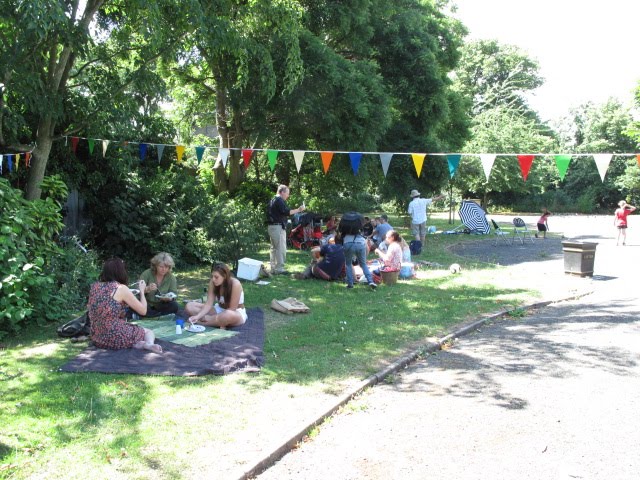


A day of lunching fun and just shows you what can happen on a little patch of forgotten green!
Don't forget the meeting this Thursday
Thanks to everyone for all there efforts to make this such a great day.
Friday, 16 July 2010
Join the West Hackney Recreation Ground User Group!

Click on the flyer above to find out more about the group and how to get involved.
The meeting is on Thursday 22nd July 7-9pm at St Paul's Church Hall.
For more info contact Imogen Sherwood on 020 8510 5420
imogen.sherwood@groundwork.org.uk
Don't forget to come along to our Big Lunch on Sunday 18th July and enjoy a family day out in our local park. See the plans for what this large space can become and help to bring it to reality!
Subscribe to:
Posts (Atom)